Category:U.S. Route 89A
Jump to navigation
Jump to search
 | number: | (eighty-nine) |
|---|---|---|
| U.S. Routes: | 69 · 70 · 71 · 72 · 73 · 74 · 75 · 76 · 77 · 78 · 79 · 80 · 81 · 82 · 83 · 84 · 85 · 87 · 89 · 90 · 91 · 92 · 93 · 95 · 96 · 97 · 98 · 99 · 101 |
U.S. Numbered Highway in Coconino County, Arizona and Kanab, Utah in the United States    | |||||
| Upload media | |||||
| Instance of | |||||
|---|---|---|---|---|---|
| Location |
| ||||
| Transport network | |||||
| Owned by | |||||
| Maintained by | |||||
| Has part(s) | |||||
| Inception |
| ||||
| Length |
| ||||
| Terminus | |||||
 | |||||
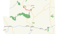
English: Media related to U.S. Route 89A, a 97.85 miles (157.47 km) U.S. Numbered Hgihway alternate route in Coconino County, Arizona and Kanab, Utah in the southwestern United States, that connects U.S. Route 89 (US 89) in Bitter Springs, Arizona with US 89 in Kanab, via Navajo Bridge. It was the original routing of US 89 and is the only road that directly connects the Arizona Strip with the rest of the state.
Subcategories
This category has the following 4 subcategories, out of 4 total.
S
- U.S. Route 89A shields (14 F)
Media in category "U.S. Route 89A"
This category contains only the following file.
-
 US 89A map.svg 1,180 × 688; 201 KB